|
Overview of maps and a number of pictures
Here you will find an overview of more maps.
Click on the thumbnail. It takes some time before some of these maps are loaded so be patient please, hit the back button the return to this page click on the thumbnails to see the map or picture. Most of these maps are edited and completed with a
signature for copyright reasons.
I want to acknowledge the help of the department of Cartography of the University of Utrecht, especially Peter van der Krogt, their great reception and the help in making the images made with an electronic camera. Without their help these pages
wouldn't exist! |
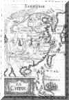
 Mercator, Asia from the Atlas part III Duisburg, 1595
Gerard Mercator junior Mercator, Asia from the Atlas part III Duisburg, 1595
Gerard Mercator junior
|
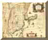
 Tartariae Sinensis by d'Anville, the title in the corner is: Mappa
Geographica ex Tabulis specialibus R.R.P.P. Iesiutarium nec non Relationibus R.P. Gerbillon per dom d'Anville Geographum Parisiensem primium Ao 1732 nunc secundum LL. projectio nis stereographica in usum translationis Germanica
Historiae Haldianae descripta per Tobiam Mayer, Soc. Cosmogr. Sodal. Curis Homannianorum Heredum Ao 1749 Tartariae Sinensis by d'Anville, the title in the corner is: Mappa
Geographica ex Tabulis specialibus R.R.P.P. Iesiutarium nec non Relationibus R.P. Gerbillon per dom d'Anville Geographum Parisiensem primium Ao 1732 nunc secundum LL. projectio nis stereographica in usum translationis Germanica
Historiae Haldianae descripta per Tobiam Mayer, Soc. Cosmogr. Sodal. Curis Homannianorum Heredum Ao 1749
|
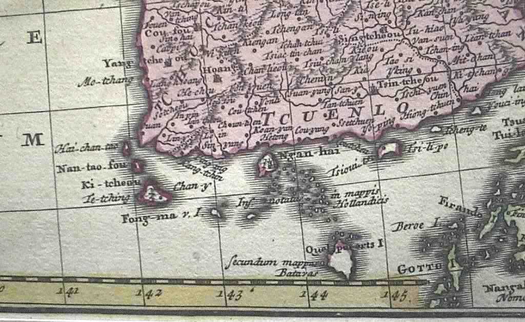
 Part of the same map but in a higher resolution. Note
the special remarks on Quelpaert Island and other remarks.: "In mappis Hollandicis" and "Secundum mappis Batavas." Also Quelpaert Island and Fong-ma are two different islands here, the names on the map indicate that the source of
the names is Chinese, the jesuits brought the data back to Europe. Part of the same map but in a higher resolution. Note
the special remarks on Quelpaert Island and other remarks.: "In mappis Hollandicis" and "Secundum mappis Batavas." Also Quelpaert Island and Fong-ma are two different islands here, the names on the map indicate that the source of
the names is Chinese, the jesuits brought the data back to Europe.
|
 Siberie ou Russe
Asiatique Tartarie Chinoise Pays de Elutes et Isles de la Japon Siberie ou Russe
Asiatique Tartarie Chinoise Pays de Elutes et Isles de la Japon
|
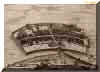
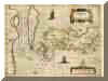
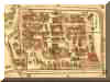
 A map of Batavia in 1681. It's title "Waere
affbeeldinge Wegens het Casteel ende Stadt Batavia gelegen op het groot Eylant Java Anno 1681" (True depiction on account of the castle and city Batavia situated on the big island Java Anno 1681) A map of Batavia in 1681. It's title "Waere
affbeeldinge Wegens het Casteel ende Stadt Batavia gelegen op het groot Eylant Java Anno 1681" (True depiction on account of the castle and city Batavia situated on the big island Java Anno 1681)
|

The coverpage of the Martinus Martini, Novus Atlas Sinensis [Dutch Issue], Amsterdam Joan Blaeu, [ca. 1655]. References: Bernard, Henri. "Les sources mongoles et chinoises de l'atlas Martini (1655)." Monumenta Serica 12 (Peking 1947)
127-144. Fuchs, Walter. The 'Mongol Atlas' of China by Chu Ssu-pên and the Kuang-yü-t'u [i.e. the revision by Lo Hung-skien]. Peiping Fu Jen University, 1946. (Monumenta Serica monograph ; 8). Haase, Yorck Alexander. Joan Blaeu, Novus Atlas
Sinensis 1655 Faksimile nach der Prachtausgabe der Herzog August Bibliothek Wolfenbüttel. Stuttgart Verlag Müller und Schindler, 1974. Höhener, Hans-Peter. "Der ältesten Europäische China-Atlas." Librarium Zeitschrift der
Schweizerischen Bibliophilen Gesellschaft 31, 1 (1988) 63-77. Majorana, Stefania. "Cartografia Europea dell'Asia Orientale sull'autenticità della cartografia del Novus Atlas Sinensis di Martino Martini il problema dell'Ezo e del Giappone."
L'Universo Revista di Divulgazione Geografica 70, 4 (1990). 518-531. Unno, Kazutaka. "Toyo Bunko shozo Maruchini Shin- shina-zucho yonshu [ = Four variants of Martini's Novus atlas Sinensis in the Toyo Bunko Library]." Toyo Bunko Shoho =
Annual Reports of the Library Department of the Toyo Bunko 15 (1983) 1-21. |
 Joan Blaeu's elegant map of Japan provided by the Jesuit Martino
Martini, who travelled in inland China for seven years. "Martini's map was to provide the most accurate depiction of the general outlines of the principal islands of Japan - Honshu, Kyushu and Shikoku - for more than a century." (John
Goss). Joan Blaeu's elegant map of Japan provided by the Jesuit Martino
Martini, who travelled in inland China for seven years. "Martini's map was to provide the most accurate depiction of the general outlines of the principal islands of Japan - Honshu, Kyushu and Shikoku - for more than a century." (John
Goss).
|
 The same map as mentioned above, only in a higher resolution. On his turn
Martini had the data for these maps based on the revised Chu Ssu-pen's maps, Kuang yü-t'u made by the Chinese scholar Lo Hung-hsien (1504 - 1564) The same map as mentioned above, only in a higher resolution. On his turn
Martini had the data for these maps based on the revised Chu Ssu-pen's maps, Kuang yü-t'u made by the Chinese scholar Lo Hung-hsien (1504 - 1564)
|
Part of the same map as mentioned above, only in a higher resolution, for the text belonging to these maps about Korea click here (17th Century Dutch with translation) |
 Blaeu China veteribus Sinarum... in Theatrum, Amsterdam 1635 W.
& J. Blaeu Blaeu China veteribus Sinarum... in Theatrum, Amsterdam 1635 W.
& J. Blaeu
|
 Cartes de Indes et de la Chine Dressee sur plusieurs
Relations particulieres Rectificiées par quelques Observations Par Guillaume de l'Isle de l'Acedemie Royale des Sciences a Amsterdam Chez Iean Covens et Corneille Mortier Cartes de Indes et de la Chine Dressee sur plusieurs
Relations particulieres Rectificiées par quelques Observations Par Guillaume de l'Isle de l'Acedemie Royale des Sciences a Amsterdam Chez Iean Covens et Corneille Mortier
|
 A map of Deshima of 1742. A map of Deshima of 1742.
|
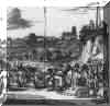
 A map of Montanus in his "Gedenkwaerdige Gesantschappen der
Oost-Indische Maatschappij in 't Vereenigde Nederland, aen de Kaisaren van Japan: Vervaetende Wonderlijke voorvallen op de Togt der Nederlandsche Gesanten; Beschrijving Van de Dorpen, Sterkten, Steden, Landschappen, Tempels, Godsdiensten, Dragten,
Gebouwen, Gewasschen, Bergen, Fonteinen, vereeuwde en nieuwe Oorlogs-daeden der Japanders: Verçiert met een groot getal Afbeeldsels in Japan geteikent:Getrokken uit de Geschriften en Reis- aentekeningen der zelve Gesanten" by Arnoldus
Meurs, Boek-verkooper en Plaetsnijder, op de Keisars-graft, schuin over de Wester-markt, in de stad Meurs. Amsterdam, 1669. A map of Montanus in his "Gedenkwaerdige Gesantschappen der
Oost-Indische Maatschappij in 't Vereenigde Nederland, aen de Kaisaren van Japan: Vervaetende Wonderlijke voorvallen op de Togt der Nederlandsche Gesanten; Beschrijving Van de Dorpen, Sterkten, Steden, Landschappen, Tempels, Godsdiensten, Dragten,
Gebouwen, Gewasschen, Bergen, Fonteinen, vereeuwde en nieuwe Oorlogs-daeden der Japanders: Verçiert met een groot getal Afbeeldsels in Japan geteikent:Getrokken uit de Geschriften en Reis- aentekeningen der zelve Gesanten" by Arnoldus
Meurs, Boek-verkooper en Plaetsnijder, op de Keisars-graft, schuin over de Wester-markt, in de stad Meurs. Amsterdam, 1669.
|
 From the same book comes this picture. From the same book comes this picture.
|
 This map is well known for its early depiction of Hokkaido and the
Islands to the North of Japan. It is based on the finding mainly of the expedition under de Vries in 1643 during which the socalledCompagnies Land was claimed (in vain). GOOS,P. Noordoost Cust van This map is well known for its early depiction of Hokkaido and the
Islands to the North of Japan. It is based on the finding mainly of the expedition under de Vries in 1643 during which the socalledCompagnies Land was claimed (in vain). GOOS,P. Noordoost Cust van
Asia van Japan tot Nova Zembla. Amsterdam 1666 Important for its early depiction of Hokkaido and the Islands to the North of Japan. Ships navigate the seas around the Siberian, Chinese and Japanese coast extending as far west as Nova Zembla, the
chart continues
eastwards to include Xantung province and Korea, mainland Japan and the land mass to the north 'Land van Eso' (Kamchatka). Eastwards the mysterious Compagnies Land is shown.
|
 "A boldly engraved map [...] showing Korea as an island, and
combining elements of Barbuda's map of China and Texeira's map of Japan (both published earlier by Ortelius). Amongst the decorative features a sea monster, deer on the North American coast, Dutch and Japanese ships, and a Chinese wind-blown land-
vehicle can be seen. A scene in a panel on the right shows an ancient Japanese torturing technique. [crucifiction of Christians]" (Potter). "A boldly engraved map [...] showing Korea as an island, and
combining elements of Barbuda's map of China and Texeira's map of Japan (both published earlier by Ortelius). Amongst the decorative features a sea monster, deer on the North American coast, Dutch and Japanese ships, and a Chinese wind-blown land-
vehicle can be seen. A scene in a panel on the right shows an ancient Japanese torturing technique. [crucifiction of Christians]" (Potter).
|
 Hondius CHINA from the Mercator Hondius Atlas Amsterdam 1606 "A
boldly engraved map [...] showing Korea as an island, and combining elements of Barbuda's map of China and Texeira's map of Japan (both published earlier by Ortelius). Amongst the decorative features a sea monster, deer on the North American coast,
Dutch and Japanese ships, and a Chinese wind-blown land- vehicle can be seen. A scene in a panel on the right shows an ancient Japanese torturing technique. [crucifiction of Christians]" (Potter). Hondius CHINA from the Mercator Hondius Atlas Amsterdam 1606 "A
boldly engraved map [...] showing Korea as an island, and combining elements of Barbuda's map of China and Texeira's map of Japan (both published earlier by Ortelius). Amongst the decorative features a sea monster, deer on the North American coast,
Dutch and Japanese ships, and a Chinese wind-blown land- vehicle can be seen. A scene in a panel on the right shows an ancient Japanese torturing technique. [crucifiction of Christians]" (Potter).
|
 Jodocus Hondius Asia 1606 Jodocus Hondius Asia 1606
|
 Janssonius China veteribus Sinarum from the Mercator Hondius Atlas,
Amsterdam 1636. Janssonius China veteribus Sinarum from the Mercator Hondius Atlas,
Amsterdam 1636.
|
 This important sea chart of the coasts of Japan was
first published in 1652 and is based on the exploration of the Dutch vessels of Maarten Gerritszoon Vries who in 1643 headed the first European expedition to chart the waters of northern Japan, Hokkaido, Sakhalin and the Southern Kuriles. Depth
soundings are given, as well as Dutch names for unknown coasts, capes, islands, straits and mountains. The weather was quite bad during the expedition, with much rain and fog, and this helps to explain some of the mistakes in this map that have
persisted for over 150 years. For instance, Vries regards Hoikkaido as part of the Asian mainland ("Land of Eso"). Kuriles islands, vaguely visible in the rain, have turned into a large landmass nort-east of Japan ("Compagnies
Land"), that some believed stretched as far as America. Korea is shown as an island as usual at the time. A variable graduation scale ("checker-board") is given to compensate for the projection distortion at this lattitude. Rumb lines
with compasses. This important sea chart of the coasts of Japan was
first published in 1652 and is based on the exploration of the Dutch vessels of Maarten Gerritszoon Vries who in 1643 headed the first European expedition to chart the waters of northern Japan, Hokkaido, Sakhalin and the Southern Kuriles. Depth
soundings are given, as well as Dutch names for unknown coasts, capes, islands, straits and mountains. The weather was quite bad during the expedition, with much rain and fog, and this helps to explain some of the mistakes in this map that have
persisted for over 150 years. For instance, Vries regards Hoikkaido as part of the Asian mainland ("Land of Eso"). Kuriles islands, vaguely visible in the rain, have turned into a large landmass nort-east of Japan ("Compagnies
Land"), that some believed stretched as far as America. Korea is shown as an island as usual at the time. A variable graduation scale ("checker-board") is given to compensate for the projection distortion at this lattitude. Rumb lines
with compasses.
|
 Johannes Janssonius, Japoniae nova descriptio from
the Atlas Novus, Amsterdam 1636 Johannes Janssonius, Japoniae nova descriptio from
the Atlas Novus, Amsterdam 1636
|
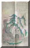
 A Korean map of Kanjin the place where Hamel stayed. (Chosôn 18th
century) A Korean map of Kanjin the place where Hamel stayed. (Chosôn 18th
century)
|
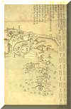
 This is another one, but more detailed (Chosôn 18th century) This is another one, but more detailed (Chosôn 18th century)
|
 A map of Cholla-do (Chosôn 18th cenury) A map of Cholla-do (Chosôn 18th cenury)
|
 Sungchon-bu Sungchon-bu
|
 Kangjin-hyon Kangjin-hyon
|
 Changhung-hyon Changhung-hyon
|
 Linschoten has it as an Island ("Ilha de
Corea") on the Far East map by Van Langeren in the 1596 Itinerario. The map is actually dated 1595, the book was not published officially before 1596, but Houtman had a version or pre-print on board on the first Dutch voyage to the East Indies
in 1595. Linschoten has it as an Island ("Ilha de
Corea") on the Far East map by Van Langeren in the 1596 Itinerario. The map is actually dated 1595, the book was not published officially before 1596, but Houtman had a version or pre-print on board on the first Dutch voyage to the East Indies
in 1595.
|
 This is a map in the book of Nieuhof,
which is discussed in the Dutch part of this website. This is a map in the book of Nieuhof,
which is discussed in the Dutch part of this website.
|
 Ortelius, Tartaria sive Magni Chami Imperium from the Atlas Epitome,
Antwerp1598 Ortelius, Tartaria sive Magni Chami Imperium from the Atlas Epitome,
Antwerp1598
|
 Ortelius Indiae Orientalis from the Atlas Theatrum, Antwerp,
1570. Japan has the typical kite shape introduced by Mercator. Mermaids, sea monsters and shipwrecks are shown. Portuguese coat of arms shown to emphasize that this is "their" part of the world. Ortelius Indiae Orientalis from the Atlas Theatrum, Antwerp,
1570. Japan has the typical kite shape introduced by Mercator. Mermaids, sea monsters and shipwrecks are shown. Portuguese coat of arms shown to emphasize that this is "their" part of the world.
|
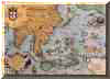
 Ortelius influential map of continental Asia after
Gastaldi. 1574 "While the Mediterranean coastline and the southern coastline [of Asia] are fairly accurate, the eastern and northern coastlines are erroneous. Especially the north-western parts with the Japanese island group is quite
mis-presented. Also many errors in placenames (e.g. Meppo for Aleppo). [...] There is no doubt about the Italian source for this map [viz. Gastaldi]." (Brandmair). References Walter 11C. Koeman Ort map 8. Van den Broecke Mercator Asia
Engravor Frans Hogenberg Ortelius influential map of continental Asia after
Gastaldi. 1574 "While the Mediterranean coastline and the southern coastline [of Asia] are fairly accurate, the eastern and northern coastlines are erroneous. Especially the north-western parts with the Japanese island group is quite
mis-presented. Also many errors in placenames (e.g. Meppo for Aleppo). [...] There is no doubt about the Italian source for this map [viz. Gastaldi]." (Brandmair). References Walter 11C. Koeman Ort map 8. Van den Broecke Mercator Asia
Engravor Frans Hogenberg
|
 This image speaks for itself, it's the coverpage of von
Siebold's book This image speaks for itself, it's the coverpage of von
Siebold's book
|
 This is the same map as of Deshima made by Titsingh, this is the Chinese
enclave.
This is the same map as of Deshima made by Titsingh, this is the Chinese
enclave.
|
 de
Wit Tabula Tartariae at majoris partis Regni Chinae Amsterdam 1662
Frederik de Wit's (1630-1706) decorative map of Tartaria, also covering
China and Japan. "An early state, used in only the earliest issues
of de Wit's atlas. For his standard atlases, from circa 1670 onwards,
the title was re-engraved and engraver's signature was erased. A detailed
decorative map of North Asia and Japan, engraved by L'Huilier. North
of Japan is Yedso, based on de Vries' accounts of his travels in that
part de
Wit Tabula Tartariae at majoris partis Regni Chinae Amsterdam 1662
Frederik de Wit's (1630-1706) decorative map of Tartaria, also covering
China and Japan. "An early state, used in only the earliest issues
of de Wit's atlas. For his standard atlases, from circa 1670 onwards,
the title was re-engraved and engraver's signature was erased. A detailed
decorative map of North Asia and Japan, engraved by L'Huilier. North
of Japan is Yedso, based on de Vries' accounts of his travels in that
part
|
Korea through
western cartographic eyes.
If you want to know more about the Dutch 17th century mapmakers, please take a look here
More maps of Korea in possession of the
Department of East Asian Languages and Cultures, USC, East Asian
Library (Definitely worth visiting)
An
interesting discussion about the name the East Sea (in Japanese)
|
|
|